|
|
|
Main
> Home
& Education > Sports > TrekMapGPS
- Annapurna Region |
 ANNAPURNA REGION is the latest in an exciting new series of Garmin-compatible
digital maps covering the major trekking and climbing regions of Nepal and
the Himalaya. TrekMapGPS products install on a PC for uploading to your GPS
unit. The maps can be previewed in Garmins MapSource (not included) or other
compatible software for route planning or reviewing. Upload to your GPS
using MapSource or an upload utility such as SendMap20 by cGPSmapper. Plan
your trip using Garmins Trip & Waypoint Manager or other compatible
software. Compatible GPS units include GPSmap, eTrex, Quest, Rino and zuno
models. ANNAPURNA REGION is the latest in an exciting new series of Garmin-compatible
digital maps covering the major trekking and climbing regions of Nepal and
the Himalaya. TrekMapGPS products install on a PC for uploading to your GPS
unit. The maps can be previewed in Garmins MapSource (not included) or other
compatible software for route planning or reviewing. Upload to your GPS
using MapSource or an upload utility such as SendMap20 by cGPSmapper. Plan
your trip using Garmins Trip & Waypoint Manager or other compatible
software. Compatible GPS units include GPSmap, eTrex, Quest, Rino and zuno
models. |
|
Buy Now |
|
Key
features of
TrekMapGPS -
Annapurna Region:
- Over
1200 searchable Points of Interest (POIs), including: 716
towns and villages (City searchable), 384 elevation spots, 12
passes, 44 summits, 91 glaciers and nearly 41 lakes, airports
and other places of interest, bridges and other man-made
objects, over 60 miscellaneous labelled locations, 120
accommodation areas and campsites
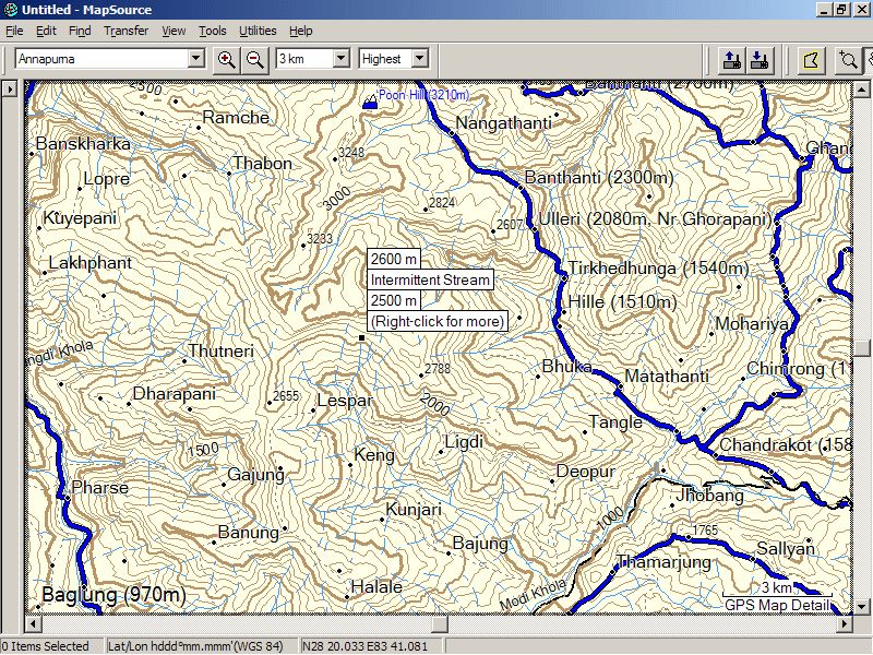
- Contours
at 100m / 500m / 1000m intervals
- All
major trekking routes, roads, tracks and paths
- Rivers
and streams
-
International and National Park borders
TrekMapGPS - Annapurna Region screenshot:
|
|
|
Product
Information
|
-
Version:
-
-
Price:
$33.00
-
Size:
-
-
License:
Shareware
-
Developer:
Mountain Stream Software
-
OS:
Windows 95, 98, ME, 2000, NT,
XP, Vista
-
Rating:

|
|
|
|